- India's Top-rated Dji Drone Store

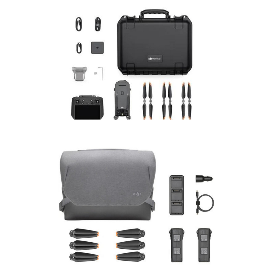
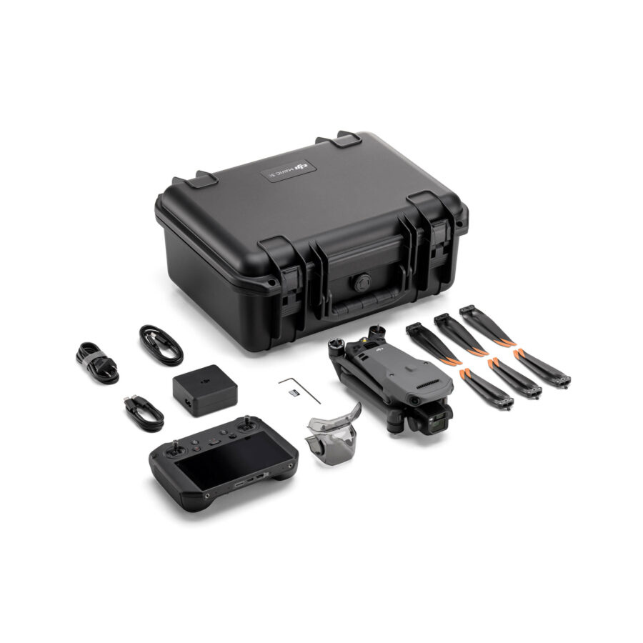
DJI Mavic 3 Multispectral Agriculture Drone With Shoulder Bag Kit
₹645,000.00
₹635,000.00

Same day dispatch, Order before 2:30 PM

30 days easy returns

24 / 7 support service

Cash on Delivery option available

1-Year Software Warranty
- Share Now :
Buy DJI Mavic 3 Multispectral Agriculture Drone With Shoulder Bag Kit at the Best Price in India
The DJI Mavic 3 Multispectral Agriculture Drone with Shoulder Bag Kit is an advanced and versatile aerial solution designed specifically for agricultural applications. This comprehensive kit includes the DJI Mavic 3 drone, equipped with a high-resolution multispectral camera, and a convenient shoulder bag for easy transportation.
The Mavic 3 Multispectral Agriculture Drone features powerful flight performance, enabling precise and efficient data collection over large agricultural areas. Its multispectral camera captures imagery in multiple spectral bands, providing valuable insights into crop health, irrigation management, and nutrient levels. This data can help farmers make informed decisions and optimize their agricultural practices.
Multispectral Imaging Technology: The DJI Mavic 3 Multispectral is equipped with advanced multispectral imaging technology, capturing data across multiple spectral bands. This feature is crucial for assessing crop health, monitoring growth, and optimizing agricultural practices by analyzing vegetation indices like NDVI and NDRE.
Precision Agriculture Flight Modes: Designed with agriculture in mind, it includes specialized flight modes that automate the process of data collection over farmland. These modes ensure comprehensive coverage and consistent data gathering, making it easier for farmers to monitor their crops effectively.
Integrated Data Analysis Tools: This drone comes with powerful data analysis tools that process multispectral images to provide actionable insights into crop health, soil condition, and water needs. These tools help in making informed decisions to improve yield and reduce resource waste.
Real-Time Data Transmission: Offers real-time data transmission, allowing farmers and agronomists to receive immediate insights into crop conditions. This feature enables quick decision-making and intervention, significantly improving crop management strategies.
Extended Flight Time: The Mavic 3 Multispectral boasts an extended flight time, ensuring that large areas of farmland can be surveyed in a single flight. This efficiency is key to maintaining regular and thorough monitoring of agricultural land.
GPS Precision Farming: Integrates GPS technology for precise farming applications, allowing for accurate mapping, field boundary detection, and targeted treatment areas. This precision reduces overlap in applications, saving time and resources.
Enhanced Connectivity for Remote Operations: Features enhanced connectivity options, including 4G and Wi-Fi, facilitating remote operations and management. This connectivity ensures that the drone can be operated from a distance, making it versatile for various agricultural tasks.
Weather-Resistant Design: The drone is built to withstand various environmental conditions, ensuring reliable operation in the diverse climates typical of agricultural settings. This resilience guarantees that data collection can continue, regardless of weather changes.
Portable and Easy to Deploy: The Mavic 3 Multispectral’s compact and foldable design makes it highly portable and easy to deploy across different fields. This portability is essential for agricultural professionals who need to monitor multiple locations.
Global Shutter Mechanism for High-Quality Imaging: Utilizes a global shutter mechanism to capture sharp, distortion-free multispectral images, crucial for accurate analysis. This feature ensures that data collected is reliable and reflective of actual crop conditions.
Obstacle Avoidance System: Includes an advanced obstacle avoidance system, enhancing safety during flights. This system prevents collisions with trees, buildings, and other obstacles, ensuring the drone’s and the crops’ safety.
Automated Data Processing Workflow: Supports an automated data processing workflow, streamlining the analysis of multispectral data. This automation facilitates a quicker turnaround from data collection to actionable insights, crucial for timely agricultural interventions.
Seamless Integration with Farm Management Software: Easily integrates with leading farm management software platforms, allowing for seamless data transfer and analysis within existing agricultural workflows. This integration enhances decision-making processes and overall farm management efficiency.
The DJI Mavic 3 Multispectral drone is a game-changer for precision agriculture, offering advanced features tailored to the needs of modern farming. From its multispectral imaging capabilities to its durability and ease of use, it provides comprehensive solutions for monitoring, analysis, and management of crops, leading to optimized agricultural practices and improved crop yields.
The DJI Mavic 3 Multispectral is designed for precision agriculture and environmental monitoring.
It is equipped with a multispectral imaging system that quickly captures crop growth information to achieve more effective crop production.
The Mavic 3M includes an RTK module that achieves centimetre-level positioning.
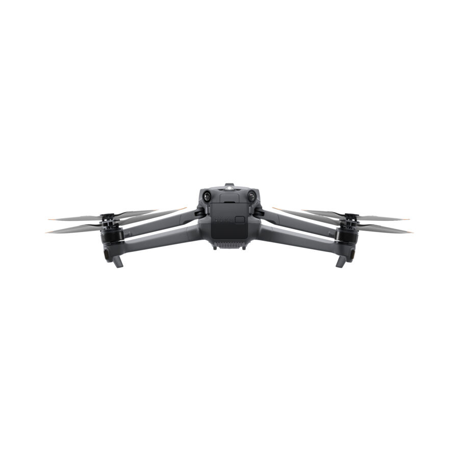
The Mavic 3 Multispectral is a highly-portable drone: It’s foldable design and 951g weight means it can be carried in a bag to enable farmers to carry out operations at anytime.
It has 43 minutes of flight time and can complete the surveying and mapping operations of an area as vast as 2 square kilometers in a single flight.


Equipped with an RTK module, the Mavic 3M offers agricultural experts the ability to perform precise aerial surveys efficiently and carefully. This advanced capability eliminates the necessity for Ground Control Points, streamlining the data collection process. This makes the Mavic 3M an indispensable tool for those in agriculture seeking to enhance their surveying practices with accuracy, speed, and without the traditional reliance on ground-based markers.
The RTK module offers precision down to the centimeter, seamlessly integrating with flight control and the camera. This synchronization happens in microseconds, ensuring the exact location of the imaging center for each photo is recorded with pinpoint accuracy. This advanced feature is essential for applications requiring highly precise data, enhancing the drone’s capabilities in mapping, surveying, and other tasks where accuracy is paramount.
The Mavic 3M has an advanced suite of safety features.
Advanced Pilot Assistance System (APAS 5.0): State-of-the-art obstacle sensing and navigation. Data from six vision and two wide-angle sensors are assessed in real-time to detect obstacles in every direction and – when using Avoid mode – reroute your flight path accordingly.
Advanced Return to Home: This intelligent function automatically adjusts your flight route to conserve battery power, ensuring your drone returns home securely with just a simple press. It’s designed to enhance safety and reliability by optimizing battery usage during flight.


The Mavic 3M offers Terrain Follow, helping you maintain an even altitude as you fly a survey mission across varying terrain.
By seamlessly adapting to changes in terrain during flight, the system ensures the accuracy and integrity of collected data, eliminating the need for adjustments during post-processing. This approach not only streamlines the data acquisition process but also enhances the quality of the information gathered, providing reliable and precise outcomes without the necessity for later corrections. Such efficiency is crucial for professionals who rely on accurate data for analysis and decision-making.
In scenarios where importing a Digital Surface Model (DSM) or local elevation data before flight isn’t possible, the Mavic 3M’s advanced collision avoidance sensors step in.
Mavic 3E Aircraft x1
Mavic 3 Intelligent Flight Battery x3
Gimbal Protector
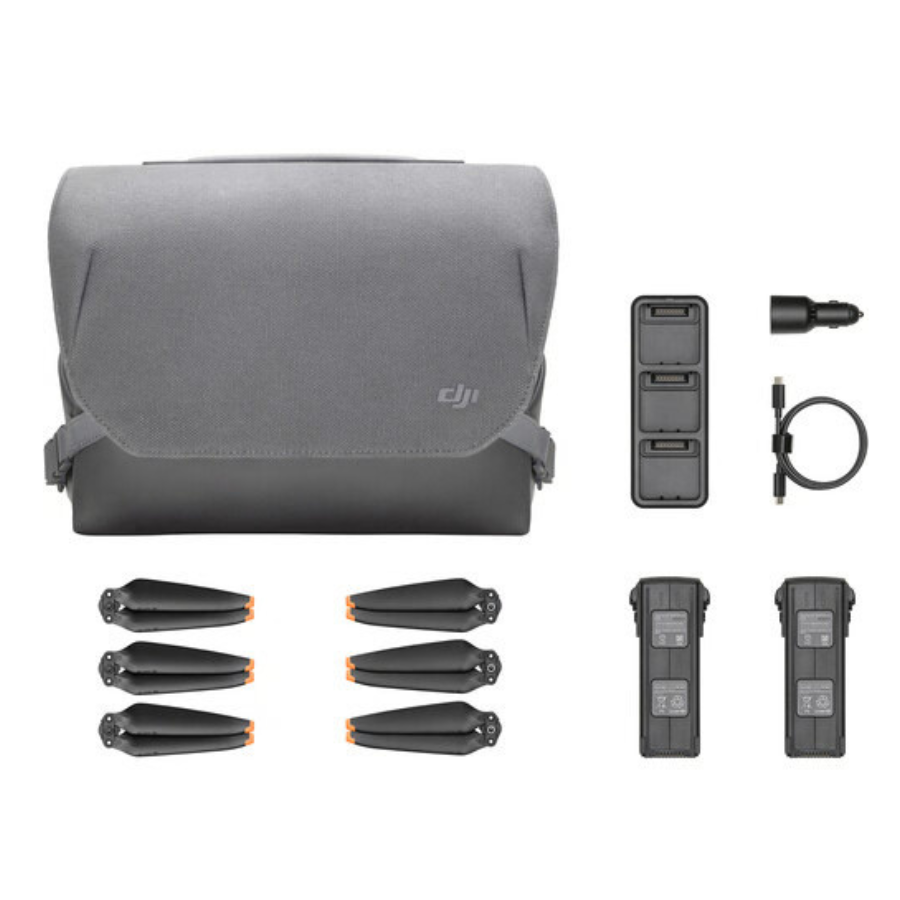
Propellers x6 Pair
RC Pro Multispectral x1
Screwdriver x1
USB-C Power Adapter x2
AC Cable x1
USB-C Cable x1
USB-C to USB-C Cable x1
Protector Case x1
Convertible Carry Bag x1
DJI 100W Battery Charging Hub for Mavic 3 Intelligent Flight Batteries
Net Weight (with propellers and RTK module) [1]
951 g
Max Takeoff Weight
1,050 g
Dimensions (Folded/Unfolded)
Folded (without propellers): 223×96.3×122.2 mm (Length×Width×Height)
Unfolded (without propellers): 347.5×283×139.6 mm (Length×Width×Height)
Diagonal Length
Diagonal: 380.1 mm
Max Ascent Speed
6 m/s (Normal Mode)
8 m/s (Sport Mode)
Max Descent Speed
6 m/s (Normal Mode)
6 m/s (Sport Mode)
Max Flight Speed (at sea level, no wind)
15 m/s (Normal Mode)
Flying forward: 21 m/s, flying sideways: 20 m/s, flying backwards: 19 m/s (Sport mode) [2]
Max Wind Speed Resistance
12 m/s [3]
Max Take-off Altitude Above Sea Level
6000 m (without a payload)
Max Flight Time (without wind)
43 minutes [4]
Max Hover Time (without wind)
37 minutes [4]
Max Flight Distance
32 km [6]
Max Tilt Angle
30° (Normal Mode)
35° (Sport Mode)
Max Angular Velocity
200°/s
GNSS
GPS + Galileo + BeiDou + GLONASS (GLONASS is supported only when RTK module is enabled)
Hovering Accuracy Range
Vertical: ±0.1 m (Vision Positioning enabled); ±0.5 m (GNSS Positioning enabled); ±0.1 m (D-RTK enabled)
Horizontal: ±0.3 m (Vision Positioning enabled); ±0.5 m (HD Positioning enabled); ±0.1 m (RTK enabled)
Operating Temperature
-10° to 40° C (14° to 104° F)
Internal Storage
N/A
Motor Model Number
2008
Propeller Model Number
9453F Enterprise Edition
Light Sensor
Built-in module
Image Sensor
4/3 CMOS
Effective Pixels: 20 MP
Lens
FOV: 84°
Equivalent focal length: 24 mm
Aperture: f/2.8 to f/11
Focus: 1 m to ∞
ISO Range
100-6400
Shutter Speed
Electronic shutter: 8-1/8000 s
Mechanical shutter: 8-1/2000 s
Max Image Size
5280×3956
Photo Shooting Mode
Single shot: 20 MP
Timelapse: 20 MP
JPEG: 0.7/1/2/3/5/7/10/15/20/30/60 s
JPEG + RAW: 3/5/7/10/15/20/30/60 s
Panorama: 20 MP (original material)
Video Resolution
H.264:
4K: 3840×2160@30fps
FHD: 1920×1080@30fps
Max Video Bitrate
4K: 130Mbps
FHD: 70Mbps
Supported File System
exFAT
Image Format
JPEG/DNG (RAW)
Video Format
MP4 (MPEG-4 AVC/H.264)
Image Sensor
1/2.8-inch CMOS, effective pixels: 5 MP
Lens
FOV: 73.91° (61.2° x 48.10°)
Equivalent focal length: 25 mm
Aperture: f/2.0
Focus: Fixed Focus
Multispectral Camera Band
Green (G): 560 ± 16 nm;
Red (R): 650 ± 16 nm;
Red Edge (RE): 730 ± 16 nm;
Near infrared (NIR): 860 ± 26 nm;
Gain Range
1x-32x
Shutter Speed
Electronic Shutter: 1/30~1/12800 s
Max Image Size
2592×1944
Image Format
TIFF
Video Format
MP4 (MPEG-4 AVC/H.264)
Photo Shooting Mode
Single shot: 5 MP
Timelapse: 5 MP
TIFF: 2/3/5/7/10/15/20/30/60 s
Video Resolution
H.264
FHD: 1920 x 1080@30fps
Video content: NDVI/GNDVI/NDRE
Max Video Bitrate
Stream: 60 Mbps
Stabilization System
3-axis mechanical gimbal (tilt, roll, pan)
Mechanical Range
Tilt: -135° to 45°
Roll: -45° to 45°
Pan: -27° to 27°
Controllable Range
Tilt: -90° to 35°
Pan: Uncontrollable
Max Control Speed (tilt)
100°/s
Angular Vibration Range
±0.007°
Sensing System Type
Omnidirectional binocular vision system, with an infrared sensor at the bottom of the aircraft
Forward
Distance Measuring Range: 0.5 m to 20 m
Detection Range: 0.5 m to 200 m
Effective Obstacle Avoidance Speed: Flight Speed ≤15 m/s
FOV: Horizontal 90°, vertical 103°
Backward
Distance Measuring Range: 0.5 m to 16 m
Effective Obstacle Avoidance Speed: Flight speed ≤12 m/s
FOV: Horizontal 90°, vertical 103°
Lateral
Distance Measuring Range: 0.5 m to 25 m
Effective Obstacle Avoidance Speed: Flight speed ≤15 m/s
FOV: Horizontal 90°, vertical 85°
Upward
Distance Measuring Range: 0.2 m to 10 m
Effective Obstacle Avoidance Speed: Flight Speed ≤6 m/s
FOV: Front and rear 100°, left and right 90°
Downward
Distance Measuring Range: 0.3 m to 18 m
Effective Obstacle Avoidance Speed: Flight speed ≤6 m/s
FOV: Front and rear 130°, left and right 160°
Operating Environment
Front, Rear, Left, Right, Above: Surfaces with clear patterns and adequate lighting (> 15 lux, environments with normal indoor fluorescent light exposure)
Below: Surfaces with diffuse reflection material and a reflectivity of >20% (such as walls, trees, people, etc.); Adequate lighting (>15 lux, environments with normal indoor fluorescent light exposure)
Video Transmission System
DJI O3 Image Transmission Industry Edition
Live View Quality
Remote Controller: 1080p/30fps
Operating Band [7]
2.400-2.4835 GHz
5.725-5.850 GHz
Max Effective Signal Distance (Unobstructed, No interference) [8]
FCC: 15 km
CE: 8 km
SRRC: 8 km
MIC: 8 km
Max Transmission Distance (Obstructed) [9]
Strong Interference (urban landscapes, residential areas, etc.): 1.5-3 km (FCC/CE/SRRC/MIC)
Medium Interference (suburban landscapes, city parks, etc.): 3-9 km (FCC), 3-6 km (CE/SRRC/MIC)
Weak Interference (remote fields, open farmland, etc.): 9-15 km (FCC), 6-8 km (CE/SRRC/MIC)
Max Download Speed
15 MB/s (with DJI RC Pro Industry Edition)
Latency (depending on environment and mobile device)
Approximately 200 milliseconds
Antennas
4 antennas, 2 transmitting and 4 receiving
Transmitter Power (EIRP)
2.4 GHz: <33 dBm (FCC), <20 dBm (CE/SRRC/MIC)
5.8 GHz: <33 dBm (FCC), <30 dBm (SRRC), <14 dBm (CE)
Other
Supports the DJI Cellular module
Supported microSD Cards
Aircraft:
Please use a memory card with a speed rating of V30 or higher, or use a memory card from the recommended list
Recommended microSD Cards
Remote Controller:
SanDisk Extreme PRO 64GB V30 A2 microSDXC
SanDisk High Endurance 64GB V30 microSDXC
SanDisk Extreme 128GB V30 A2 microSDXC
SanDisk Extreme 256GB V30 A2 microSDXC
SanDisk Extreme 512GB V30 A2 microSDXC
Lexar 667x 64GB V30 A2 microSDXC
Lexar High-Endurance 64GB V30 microSDXC
Lexar High-Endurance 128GB V30 microSDXC
Lexar 667x 256GB V30 A2 microSDXC
Lexar 512GB V30 A2 microSDXC
Samsung EVO Plus 64GB V30 microSDXC
Samsung EVO Plus 128GB V30 microSDXC
Samsung EVO Plus 256GB V30 microSDXC
Samsung EVO Plus 512GB V30 microSDXC
Kingston Canvas Go! Plus 128GB V30 A2 microSDXC
Kingston Canvas React Plus 128GB V90 A1 microSDXC
Aircraft:
SanDisk Extreme 32GB V30 A1 microSDHC
SanDisk Extreme PRO 32GB V30 A1 microSDHC
SanDisk Extreme 512GB V30 A2 microSDXC
Lexar 1066x 64GB V30 A2 microSDXC
Kingston Canvas Go! Plus 64GB V30 A2 microSDXC
Kingston Canvas React Plus 64GB V90 A1 microSDXC
Kingston Canvas Go! Plus 128GB V30 A2 microSDXC
Kingston Canvas React Plus 128GB V90 A1 microSDXC
Kingston Canvas React Plus 256GB V90 A2 microSDXC
Samsung PRO Plus 256GB V30 A2 microSDXC
Capacity
5000 mAh
Standard Voltage
15.4 V
Max Charging Voltage
17.6 V
Battery Type
LiPo 4S
Chemical System
Lithium Cobalt
Energy
77 watt-hours
Weight
335.5 g
Charging Temperature
5° to 40° C (41° to 104° F)
Input
100V to 240V (AC), 50Hz to 60Hz, 2.5A
Output Power
100 Watts
Output
Maximum output power of 100 Watts (total)
When both the ports are used, the maximum output power of one interface is 82 W, and the charger will dynamically allocate the output power of the two interfaces according to load power.
⊕ Charging Hub
Input
USB-C: 5V to 20V, 5.0A
Output
Battery Port: 12V to 17.6V, 8.0A
Rated Power
100 Watts
Charging Type
3 batteries on charging rotation
Charging Temperature
5° to 40° C (41° to 104° F)
Dimensions
50.2×40.2×66.2 mm (Length×Width×Height)
Weight
24±2 g
Interface
USB-C
Power
Approximately 1.2 watts
RTK Position Accuracy
Fixed RTK:
Horizontal: 1 cm + 1 ppm; Vertical: 1.5 cm + 1 ppm
DJI agriculture drone
Agriculture drone uses
Agriculture drone benefits
Agriculture drone price in India
What is multispectral imaging, and how does it benefit agriculture?
Multispectral imaging captures data across several specific wavelengths of light, including those beyond the visible spectrum. This technology helps in assessing plant health, moisture levels, and nutrient presence, enabling precise agriculture practices by identifying areas that need attention, ultimately leading to improved crop yields and resource management.
Can the DJI Mavic 3 Multispectral detect crop diseases?
Yes, by analyzing data from different spectral bands, the DJI Mavic 3 Multispectral can help detect signs of disease or pest infestation before they become visible to the naked eye. Early detection allows for timely intervention, reducing potential crop damage.
How accurate is the GPS technology in the Mavic 3 Multispectral?
The GPS technology integrated into the Mavic 3 Multispectral is highly accurate, enabling precise mapping, field boundary detection, and targeted application areas. This accuracy is crucial for reducing overlaps in applications and ensuring efficient use of resources.
What types of crops can benefit from the DJI Mavic 3 Multispectral?
Virtually all types of crops can benefit from the insights provided by the DJI Mavic 3 Multispectral, including grains, vegetables, fruits, and specialty crops. The drone’s technology is versatile enough to support various agricultural practices, from large-scale farming to precision viticulture.
Is the DJI Mavic 3 Multispectral easy to operate for someone new to drone technology?
Yes, the DJI Mavic 3 Multispectral is designed with user-friendliness in mind. It comes equipped with automated flight modes and an intuitive interface, making it accessible for users with varying levels of drone piloting experience, including those new to drone technology.
Can the drone operate in windy conditions?
The DJI Mavic 3 Multispectral is designed to be robust and can operate in various weather conditions, including windy scenarios. Its weather-resistant design and stability ensure reliable data collection even in less than ideal weather conditions.
How does the real-time data transmission work? Real-time data transmission on the DJI Mavic 3 Multispectral works via enhanced connectivity options like 4G and Wi-Fi. This feature allows the operator to receive immediate insights into the crop conditions on their device, facilitating on-the-spot decision-making and adjustments.
How long does it take to process the multispectral data collected by the drone?
The automated data processing workflow of the Mavic 3 Multispectral streamlines the analysis, significantly reducing the time from data collection to actionable insights. The exact processing time can vary based on the amount of data and the specific analysis required, but it is generally efficient, allowing for timely interventions.
Can the DJI Mavic 3 Multispectral be integrated with existing farm management software?
Yes, the Mavic 3 Multispectral seamlessly integrates with leading farm management software platforms, allowing for easy transfer and analysis of data within existing agricultural workflows. This integration helps in enhancing decision-making processes and improving overall farm management efficiency.
What maintenance does the DJI Mavic 3 Multispectral require? T
o ensure optimal performance, the DJI Mavic 3 Multispectral requires regular maintenance, including cleaning the camera lenses and sensors, checking the propellers for damage, and ensuring the batteries are charged and stored properly. Following the manufacturer’s maintenance guidelines will help maintain the drone’s longevity and reliability.
Love from Clients
“ Lorem Ipsum is simply dummy text of the printing and typesetting industry. Lorem Ipsum has been the industry's standard dummy text ever since”

Lorem Ipsum
Lorem Ipsum“Lorem Ipsum is simply dummy text of the printing and typesetting industry. Lorem Ipsum has been the industry's standard dummy text ever since”

Lorem Ipsum
Lorem Ipsum“Lorem Ipsum is simply dummy text of the printing and typesetting industry. Lorem Ipsum has been the industry's standard dummy text ever since”

Lorem Ipsum
Lorem Ipsum“Lorem Ipsum is simply dummy text of the printing and typesetting industry. Lorem Ipsum has been the industry's standard dummy text ever since”